
The Dutch and the Afsluitdijk
A thousand years against the sea

The Afsluitdijk is a wall twenty miles long, thrown across the open mouth of an inland sea. It carries a road, a bicycle path, and the unbroken weight of the North Sea. When its final gap was shut on a grey afternoon in May 1932, an inland sea ceased to exist. The Zuiderzee — the brackish gulf that for seven hundred years had carved itself out of the heart of Holland — became, in a single tide, a lake. Within a few years the lake was fresh. Within a generation the Dutch had drained the first polders from its bed and built farms and roads and airports on what had been the floor of an ocean.
The dam is one of the engineering wonders of the twentieth century. But the Afsluitdijk was not really the work of the twentieth century. It was the final stone in a wall a thousand years long.
Long before the Romans reached the mouth of the Rhine, the people who would become the Dutch were pushed northward. The high ground of the continent was already taken; the forests of the interior held by tribes who had no interest in sharing them. What remained was what no one else wanted. The great delta where three rivers met the sea, a flat soaking sponge of peat and salt marsh and tidal flat, half land and half water, scrubbed twice a day by the tides. These marshlands were uninhabitable. The Frisians inhabited them.
They began, more than two thousand years ago, by raising mounds. They piled clay and dung and refuse into great low hills — terpen, the Frisians called them; wierden, the Saxons — and on these little artificial islands they built their longhouses and grazed their cattle and waited out the floods. There are more than a thousand of these mounds still rising from the fields of Friesland and Groningen, some of them fifteen feet high, the bones of their builders still buried in their flanks.
The first dikes were small things — earthen walls thrown up around a single field, a single pasture, to keep the salt out long enough for a crop to grow. By the eleventh century, ring-dikes encircled whole villages. By the twelfth, dikes ran for miles along the rivers, joined together, became continuous. The drowned land behind them was reclaimed acre by acre. By the late Middle Ages, the Dutch had bent the windmill to the work of drainage, and now they were not merely walling out the sea but pumping it back, draining lakes that had stood since the last ice age, exposing the rich black bottom-mud and turning it into farmland. The Beemster, drained in 1612, is still a perfect grid of fields thirteen feet below sea level, its dairy cattle grazing where herring once swam.
By the time the Dutch Republic was the wealthiest nation in Europe, perhaps a fifth of its territory had been made by hand. The country existed because it had been built. God schiep de wereld, maar de Nederlander schiep Nederland. God created the world, but the Dutchman created the Netherlands. The nation was a continuous act of self-creation by a people believing themselves to be chosen by God.
But the sea took back what it could. The Zuiderzee itself was a wound — once a freshwater lake called Lake Flevo, fringed by peat bog and farmland, until in the storm of 1170 the North Sea broke through the dunes and began to devour the land. Each generation lost more. The St. Lucia’s flood of 1287 drowned somewhere between fifty and eighty thousand people in a single night, one of the deadliest natural disasters in European history outside the plagues, and when the waters receded the Zuiderzee had its modern shape: a great salt arm reaching deep into the country, nearly two thousand square miles of ocean where there had been pasture and peat.
It was the Frisians who named it. Zuiderzee — South Sea — may seem a misleading name for a body of water in the north of the country. But the Frisians lived along its top edge, and to a man standing on the dunes of Friesland looking out at the enormous, tempestuous body of water that fed on his coast, the water was to his south. Men are provincial animals.
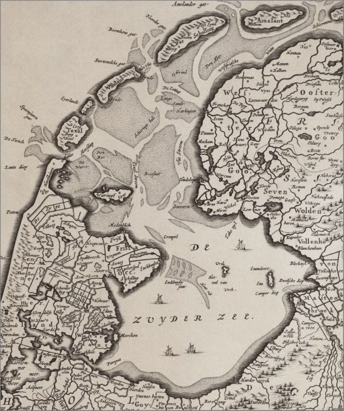
The towns along its new coast — Hoorn, Enkhuizen, Stavoren — grew rich on its herring. They also grew used to its rage. The All Saints’ Flood, the St. Elizabeth’s Flood, the Christmas Flood of 1717 that killed fourteen thousand in a single night across the northern provinces. The Zuiderzee was a waterwolf — the old Dutch word for a body of water that fed itself by eating land. For seven hundred years the Dutch tolerated it because they could not imagine an alternative. To close the Zuiderzee would mean building a dam across an open sea — twenty miles of wall through tides that ran at five knots, in water sixty feet deep in places, on a foundation of soft marine clay that would swallow stone. It was the equivalent, in scale and difficulty, of throwing a causeway across the English Channel. Men had contemplated such a feat before. Hendrik Stevin had sketched one in the seventeenth century; others had followed in every generation since. None had been built. Nowhere in Europe — nowhere in the world — had any people closed a stretch of open sea this wide, this deep, this fast.
Cornelis Lely was born in Amsterdam in 1854, the son of a paper merchant. He studied to be an engineer, came up through the Society for the Reclamation of the Zuiderzee, and by his early thirties was the leading expert on the inland sea. In 1891, at the age of thirty-six, he submitted to the Dutch government a complete plan: a great enclosing dam from the North Holland coast to the Frisian shore, the inland body to be drained gradually into freshwater, and four enormous polders to be reclaimed from its bed. Lely proposed building a new province out of ocean.
The government rejected it. It was too expensive. The fishing towns along the Zuiderzee — Volendam, Marken, Urk — would lose their livelihoods. The agricultural lobby did not want more farmland flooding the market.
Lely went into politics to realise his vision. He became Minister of Water Management three separate times — in 1891, in 1897, in 1913 — and each time he pushed his plan, and each time it was deferred. The dam he had designed at thirty-six was still on paper when he turned sixty.
In January 1916 a winter storm broke through the Zuiderzee dikes in a dozen places, drowning villages along the inland coast and a chunk of the country around Amsterdam. The flood killed only nineteen people, but it killed them in places that had thought themselves safe, and the political resistance to Lely’s plan collapsed almost overnight. In June 1918 the Zuiderzee Act passed the States General. Lely was sixty-four years old. He had been waiting twenty-seven years.
Construction began in 1927. Four enormous work-yards were thrown up along the chosen line and from each, gangs of men began to push out into the open sea. They had to invent the work as there was no precedent to copy. Dredges scooped boulder clay from the bottom of the Zuiderzee itself, so that the dam was built from the bed of the sea it was to close. Barges then dumped the clay in two parallel lines along the planned route, sand was poured between the lines, and a second layer of clay was laid over the top to seal it. Beneath it all, sunk on the soft marine floor, lay great mats woven from osier — the supple willow Dutch farmers had been cutting for baskets since the Middle Ages — weighted down with basalt boulders. It was the only foundation the engineers had found that would not slowly disappear into the mud.
The fleet was an entire navy of construction. Twenty-seven dredges, thirteen floating cranes, a hundred and thirty-two barges, eighty-eight tugs. To build the middle of the dam they built work-platforms first — two artificial islands, Kornwerderzand and Breezanddijk, raised out of the open sea solely to give the men somewhere to stand. By the time the work was done, the dam contained roughly thirty-seven million cubic metres of clay and sand. Fourteen Great Pyramids of Giza, dropped into the Zuiderzee.
Around ten thousand men passed through the camps; five thousand worked the line on any given day — Frisians, Hollanders, men from the depressed peat towns of the east, men with no other work in a country sliding into depression. They worked through gales that washed entire sections of fresh-laid embankment back into the sea. They worked in winter, faces black with frostbite under their woollen caps, and in summer, swarmed by midges off the mudflats. They lived in barracks on barges and rafts and on the dam itself as it grew, surrounded by water on all sides, building the land that would house them.
Shipworm — the marine mollusc the Dutch called paalworm, the pile-worm — ate through the willow mat base, and the galvanised steel wire holding the bundles together had been chewed away by salt. The foundation was failing under the dam they had built on top of it. Barite was imported from Germany to replace the rotten willow. Whole stretches of the floor were rebuilt in deep water, in winter, while the men above kept dumping clay.
The dam was finally closed on 28 May 1932 at a place called the Vlieter, eight miles east of the North Holland shore. The last gap was perhaps fifty metres wide. On either side, the dam stood finished. Through the gap the tide ran like a river, four knots, five knots, in and out twice a day, the last living artery of the Zuiderzee.
The engineers had waited for slack water — the moment between tides when the current pauses and the sea forgets which way to run. Two columns of barges loaded with boulder clay converged on the gap from either side, watched by a row of film cameras strung along the new dam, and dumped their cargo at once into the narrowing channel. The water boiled and foamed and could not get through. In a few minutes it was over. The Zuiderzee was sealed.
Lely had died three years earlier at seventy-four. A statue of Cornelis Lely stands now at the western end of the dam, looking out over his works, the great apogee of Dutch contest against the sea.
Great article!
Not a topic I've given much thought to before, but this was a delightful compelling read, full of drama and human spirit!